Purchasing an aerial photo
Who is it for?
For purchasing a product, you need to complete the registration process and log in to the website
Description
The Historical Archive of the Italian Military Geographic Institute holds more than 300,000 aerial photos of the Italian territory taken between 1927 and 2010.
Photograms starting from 1937 can be searched and purchased in the “geo product” section on our website.
Photograms prior to 1937 cannot be searched and purchased online. For more information please send an email to: info@geomil.esercito.difesa.it
As photograms are not ready for an immediate download, they will be delivered presumably within 15 days.
Operating Instructions
A brief summary about the main steps to follow:
To search and purchase an aerial photo online, please connect to the “Geoprodotti” page. By clicking on the map or clicking and dragging the mouse over it, select the area on which to request the list of photograms.
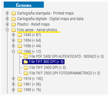
Select "Foto aerea - Aerial photos" in the menu on the left, then choose one of the flight years by opening the relative folder and select one of the purchase methods:
- File PDF 2400 DPI autenticato - signed
- File TIFF 800 DPI
- File TIFF 2400 DPI
- File TIFF 2500 DPI fotogrammetrico

A list of photograms that meet the chosen geographic and time criteria will then appear.

Each photogram has an identifier in the form “AAAA - altitude - sheet-swipe-photo_mode_of_purchase” (e.g. “1963 - 3800 - 105-XVII-28 AERIAL PHOTOS: TIFF FILE AT 800 DPI” identifies the 1963 flight, altitude 3800, sheet number series 100V 105, swipe XVII, photogram 28, here purchasable as an 800 DPI scan).
The net price of the product will also appear (e.g., 12.0€).
By clicking on the photogram identifier, you can see the low-resolution preview and get other grading data.
You will also find three useful functions allowing to:
 place the photogram in the shopping cart for purchase;
 zoom in on the map at the coverage of the photogram;
 highlight on the map the area covered by the photogram.
Tools
For purchasing the photograms, you must register and access the site as follows:
- ARE YOU AN ITALIAN (WITHOUT VAT NUMBER)? You can quickly register or access the site via SPID (Public System for the Management of Digital Identity)
- ARE YOU A EUROPEAN CITIZEN (WITHOUT VAT NUMBER)? You can register or access the site by using your username e password
- ARE YOU A CUSTOMER WITH VAT NUMBER (COMPANY, INDIVIDUAL COMPANY)? ARE YOU A FOREIGN CUSTOMER? Register or access the site by using your username e password
Outcomes
Each photogram can be purchased as follows:
- Signed 2400 DPI PDF file
The PDF file, generated from the 2400 DPI scan of the entire aerial photogram, is digitally signed - TIFF 800 DPI non-photogrammetric
Scanning of the entire photogram - TIFF 2400 DPI non-photogrammetric
Scan of the entire photogram - TIFF 2500 DPI photogrammetric
Scan the entire photogram.
Scan with a 2500 dpi photogrammetric scanner allows the use of stereoscopic (3D) methodologies in which at least two contiguous frames are essential.
Scans at 2400 DPI and 2500 DPI, for photo interpretation research, are almost equivalent.
Times and deadlines
Sending the purchased frame will take place 15-20 days after payment.
Cost
Cost of photograms depends on their typology
Access the service
For purchasing the photograms, you must register and access the site as follows:
- ARE YOU AN ITALIAN (WITHOUT VAT NUMBER)? You can quickly register or access the site via SPID (Public System for the Management of Digital Identity)
- ARE YOU A EUROPEAN CITIZEN (WITHOUT VAT NUMBER)? You can register or access the site by using your username e password
- ARE YOU A CUSTOMER WITH VAT NUMBER (COMPANY, INDIVIDUAL COMPANY)? ARE YOU A FOREIGN CUSTOMER? Register or access the site by using your username e password
Additional information
More information available in the Product Specifications - Aerial photography section.
Terms of service
For details on deadlines, requirements and other important information, please read the terms and conditions of use.

