Operating Instructions
A brief summary about the main steps to follow:
To search and purchase an aerial photo online, please connect to the “Geoprodotti” page. By clicking on the map or clicking and dragging the mouse over it, select the area on which to request the list of photograms.
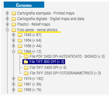
Select "Foto aerea - Aerial photos" in the menu on the left, then choose one of the flight years by opening the relative folder and select one of the purchase methods:
- File PDF 2400 DPI autenticato - signed
- File TIFF 800 DPI
- File TIFF 2400 DPI
- File TIFF 2500 DPI fotogrammetrico

A list of photograms that meet the chosen geographic and time criteria will then appear.

Each photogram has an identifier in the form “AAAA - altitude - sheet-swipe-photo_mode_of_purchase” (e.g. “1963 - 3800 - 105-XVII-28 AERIAL PHOTOS: TIFF FILE AT 800 DPI” identifies the 1963 flight, altitude 3800, sheet number series 100V 105, swipe XVII, photogram 28, here purchasable as an 800 DPI scan).
The net price of the product will also appear (e.g., 12.0€).
By clicking on the photogram identifier, you can see the low-resolution preview and get other grading data.
You will also find three useful functions allowing to:
 place the photogram in the shopping cart for purchase;
 zoom in on the map at the coverage of the photogram;
 highlight on the map the area covered by the photogram.

